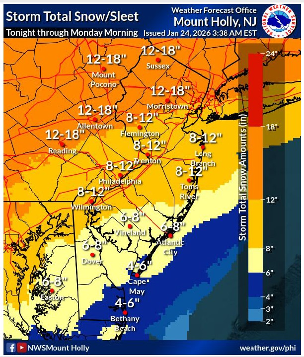
Snowfall amounts reduced slightly, with highest reductions south and east of the I-95 corridor as confidence increases in mixing occurring. Impacts are unchanged as the combination of snow/sleet/freezing rain will bring major disruptions to the area. Widespread snow and sleet totals ranging from 4″ to 8″ in southern zones. Snowfall rates near 1-2″ per hour likely (60-80%) during the daytime period Sunday.
Narrow corridor of highest ice accumulations shifted southeastward, now more over South Jersey and Delmarva rather than the I-95 corridor. Confidence is low on where the highest ice totals are.
High confidence in widespread MAJOR impacts expected for most of the region.
Heavy snow and some ice accumulation will make travel dangerous or impossible. Expect widespread road closures and significant delays on major interstates and highways.
The highest ice accumulations were also shifted slightly southeast. Some isolated power outages possible with ice accumulations potentially ranging from 0.1″ to 0.3″ when snow will mix with or change to sleet and freezing rain across southern NJ beginning Sunday afternoon into Sunday evening.
No changes to the Winter Storm Warning, which remains in effect from tonight until Monday morning. A Cold Weather Advisory is in effect where wind chills and temperatures in the single digits to below zero are expected for several consecutive nights.