NJDOT issues emergency regulation lowering speed limit to 35 mph 

Order also applies to NJ Turnpike, Garden State Parkway and Atlantic City Expressway

New Jersey Department of Transportation (NJDOT) Acting Commissioner Joe Bertoni has issued an Emergency Traffic Regulation Order that temporarily lowers all posted speed limits to 35 miles per hour on Interstate and State highways in New Jersey starting at 12:01 a.m. Sunday, January 25. The speed limit reduction applies to:

  • All Interstate highways in New Jersey
  • All U.S. and State highways in New Jersey
  • The New Jersey Turnpike
  • The Garden State Parkway
  • The Atlantic City Expressway

The speed limit reduction is being made out of an abundance of caution based on the forecast for heavy snow, ice, and strong winds statewide. Winter weather is expected to begin early Sunday morning, January 25 and continue into Monday, January 26, which could make driving conditions treacherous throughout the state.

Continue reading “NJDOT issues emergency regulation lowering speed limit to 35 mph “

Camden County Public Works crews on the job as severe winter weather impacts South Jersey

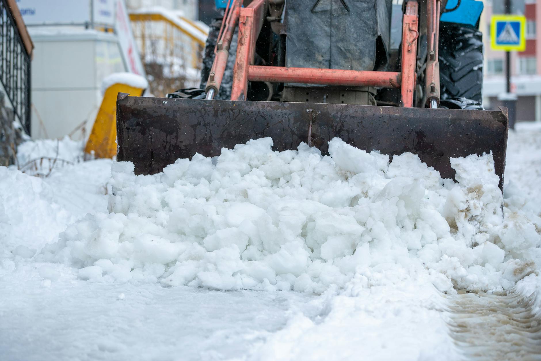
snow clearing
Photo by Sergei Starostin on Pexels.com

As a major winter storm begins to impact South Jersey, crews from the Camden County Department of Public Works are being deployed throughout Camden County to ensure the county’s 1,200 lane miles of road are safe and passable for motorists.

“We have not seen a snowstorm of this caliber in several years, and we are expecting hazardous road conditions across Camden County,” said Commissioner Jonathan Young, liaison to the Department of Public Safety. “It is crucial that everyone stay off the roads for the duration of this storm unless travel is absolutely essential.”

Continue reading “Camden County Public Works crews on the job as severe winter weather impacts South Jersey”

Dangerous Cold and Winter Storm Briefing

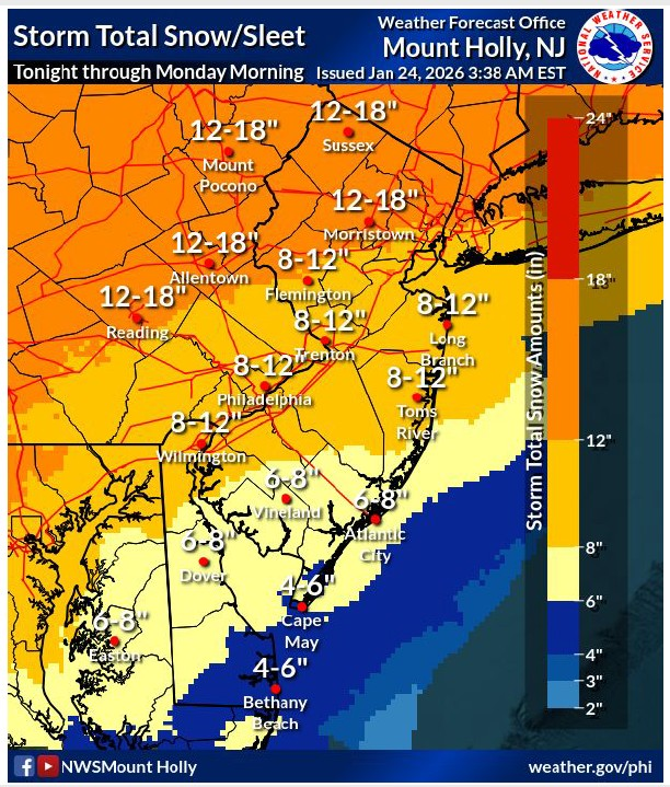
  • Snowfall amounts reduced slightly, with highest reductions south and east of the I-95 corridor as confidence increases in mixing occurring. Impacts are unchanged as the combination of snow/sleet/freezing
    rain will bring major disruptions to the area.  Widespread snow and sleet totals ranging from 4″ to 8″ in southern zones.  Snowfall rates near 1-2″ per hour likely (60-80%) during the daytime period Sunday.
  • Narrow corridor of highest ice accumulations shifted southeastward, now more over South Jersey and Delmarva rather than the I-95 corridor. Confidence is low on where the highest ice totals are.
  • High confidence in widespread MAJOR impacts expected for most of the region. 
  • Heavy snow and some ice accumulation will make travel dangerous or impossible.  Expect widespread road closures and significant delays on major interstates and highways.  
  • The highest ice accumulations were also shifted slightly southeast. Some isolated power outages possible with ice accumulations potentially ranging from 0.1″ to 0.3″ when snow will mix with or change to sleet and freezing rain across southern NJ beginning Sunday afternoon into Sunday evening.
  • No changes to the Winter Storm Warning, which remains in effect from tonight until Monday morning. A Cold Weather Advisory is in effect where wind chills and temperatures in the single digits to below zero are expected for several consecutive nights.  

New Jersey American Water Readies for Winter Storm

State’s largest water and wastewater utility prepares for snowstorm and shares safety tips for customers
 New Jersey American Water is preparing for forecasted snowstorm and freezing wintery mix this weekend. The company has initiated readiness efforts to mitigate potential impacts to its water and wastewater plants and distribution systems. 

“We are committed to providing safe and reliable water service to our customers, even through extreme weather conditions,” said Benjamin Morris, vice president of operations for New Jersey American Water. “Our team of experts is highly trained on emergency preparedness, response and management and is ready to handle any service disruptions that may come our way.”

Continue reading “New Jersey American Water Readies for Winter Storm”

Camden County Office of Emergency Management issues “Code Blue”

The Camden County Office of Emergency Management declared that Camden County will be under a Code Blue Advisory from for the following dates and times due to projected dangerously low temperatures by the National Weather Service:

Friday January 23, 7:00 p.m. – Wednesday January 28, 7:00 a.m.

• Projected temperature: Between 3°F and 30°F

Code Blue Advisories are declared when the National Weather Service predicts that the temperature is 32 degrees Fahrenheit or lower, or the wind chill temperature will be zero degrees Fahrenheit or lower for a period of two hours or more.

“As temperatures fall to dangerously low levels, it is critical that our residents have access to a safe place to stay warm,” said Commissioner Jonathan Young, liaison to the Camden County Department of Public Safety. “We urge everyone to check in on vulnerable neighbors, ensure heating systems are working properly, and bring pets indoors.”

Continue reading “Camden County Office of Emergency Management issues “Code Blue””

Camden County is Prepared For Severe Winter Storm

(Lindenwold, NJ) – As a heavy winter storm is forecasted to impact South Jersey beginning Sunday, Jan. 25 into Monday, Jan. 26, the Camden County Board of Commissioners and the Camden County Department of Public Works are prepared to handle any and all emergencies due to the weather. Southern New Jesey is expected to receive anywhere from 8 -12 inches of snow.

“We have not seen a snowstorm of this magnitude and severity in over a decade. The safety of the residents of Camden County is paramount and our number one priority,” said Commissioner Jonathan Young, liaison to the Department of Public Safety. “The more people we have out on the roads, the greater chance there is of an emergency situation unfolding. If it is not absolutely necessary, please stay home, and off the roads.”

Camden County’s Department of Public Works and Camden County Parks Department will be working throughout the duration of the storm to ensure that county roadways are passable, and to respond to downed trees and debris. Additionally, due to the impeding inclement weather, all branches of the Camden County Library System will be closed on Sunday, Jan. 25.

Continue reading “Camden County is Prepared For Severe Winter Storm”

Heavy Great Lakes Snow through Friday; Extreme Cold and Potential for Major Winter Storm Late Week into this Weekend

Detailed Forecast

https://www.bing.com/search?FORM=ARPSEC&PC=ARPL&PTAG=1332&q=mt.%20holly%20weather%20alert%20station&ntref=1

Multiple clipper systems will bring cold temperatures and enhance lake-effect snow downwind of the Great Lakes. An arctic blast will bring frigid temperatures accompanied with gusty winds that may lead to dangerous wind chills beginning in the Northern Plains Thursday before expanding to the South and East. An expansive winter storm will start Friday in the Southern Rockies/Plains and Mid-South. Read More >

Current conditions at

Philadelphia, Philadelphia International Airport (KPHL)

Lat: 39.87°NLon: 75.23°WElev: 7ft.

Mostly Cloudy

29°F

-2°C

Humidity34%
Wind SpeedS 9 mph
Barometer30.53 in (1033.9 mb)
Dewpoint4°F (-16°C)
Visibility10.00 mi
Wind Chill21°F (-6°C)
Last update21 Jan 10:54 am EST

More Information:

Local Forecast OfficeMore Local Wx3 Day HistoryHourly Weather Forecast

Continue reading “Heavy Great Lakes Snow through Friday; Extreme Cold and Potential for Major Winter Storm Late Week into this Weekend”

Camden County Office of Emergency Management issues “Code Blue”

Monday January 12, 7:00 p.m. – Tuesday January 13, 7:00 a.m.

• Projected temperature: 30°F

Code Blue Advisories are declared when the National Weather Service predicts that the temperature is 32 degrees Fahrenheit or lower, or the wind chill temperature will be zero degrees Fahrenheit or lower for a period of two hours or more.

“As temperatures fall to dangerously low levels, it is critical that our residents have access to a safe place to stay warm,” said Commissioner Jonathan Young, liaison to the Camden County Department of Public Safety. “We urge everyone to check in on vulnerable neighbors, ensure heating systems are working properly, and bring pets indoors.”

Continue reading “Camden County Office of Emergency Management issues “Code Blue””

Camden County Office of Emergency Management issues “Code Blue”

(Gloucester Township, NJ) – The Camden County Office of Emergency Management declared that Camden County will be under a Code Blue Advisory from for the following dates and times due to projected dangerously low temperatures by the National Weather Service:

Tuesday December 30, 7:00 p.m. – Wednesday December 31, 7:00 a.m.
• Projected temperature: 27°F
Wednesday December 31, 7:00 p.m. – Friday January 2, 7:00 a.m.
• Projected temperature: Low of 18°F

Code Blue Advisories are declared when the National Weather Service predicts that the temperature is 32 degrees Fahrenheit or lower, or the wind chill temperature will be zero degrees Fahrenheit or lower for a period of two hours or more.

Continue reading “Camden County Office of Emergency Management issues “Code Blue””

New Year’s Eve forecast calls for colder air in the Northeast, rain returns to the West

AccuWeather® Global Weather Center – Dec. 29, 2025 – People planning to celebrate the new year at outdoor events should plan for colder air in the Northeast, while families heading to the parade and the bowl game in Southern California should prepare for rain.


“The stormy stretch after Christmas Day is finally winding down, just in time to celebrate the new year. Snow showers and some periods of heavier snow could create some travel trouble across the Great Lakes and Northeast on New Year’s Eve. While there still will be pockets of poor travel through New Year’s Day, much of the country will have good travel conditions following the back-to-back winter storms that swept through parts of the Midwest and Northeast,” AccuWeather® Meteorologist Elizabeth Danco said.


New York City Forecast


AccuWeather® expert meteorologists say there could be more than confetti in the air at the New Year’s Eve ball drop in New York City this year.  

“People heading out to the ball drop or other outdoor celebrations should bundle up. Flurries could be flying in Times Square before the ball drops,” Danco said. “The AccuWeather RealFeel Temperature before midnight will drop into the teens. Make sure you have a winter coat, hat, gloves and a scarf. Winds could gust around 15 mph.”

The forecast to ring in 2026 in New York City is drastically different from last year’s celebration. 

“It will feel roughly 20 to 30 degrees colder outside compared to last year, but at least everyone should stay much drier. Showers and thunderstorms soaked revelers in New York City last year,” Danco said

Courtesy: AccuWeather