
Dense Fog Advisory until 10:00AM Wednesday

* WHAT…Visibility one quarter to one half mile in dense fog.

* WHERE…Portions of Delaware, northeast Maryland, New Jersey, and southeast Pennsylvania.

* WHEN…From 10 PM this evening to 10 AM EST Wednesday.

* IMPACTS…Low visibility could make driving conditions hazardous.

* AFFECTED AREAS: NEW CASTLE … KENT … INLAND SUSSEX … DELAWARE BEACHES … KENT … QUEEN ANNE’S … TALBOT … CAROLINE … SUSSEX … WARREN … MORRIS … HUNTERDON … SOMERSET … MIDDLESEX … WESTERN MONMOUTH … EASTERN MONMOUTH … MERCER … SALEM … GLOUCESTER … CAMDEN … NORTHWESTERN BURLINGTON … OCEAN … CUMBERLAND … ATLANTIC … CAPE MAY … ATLANTIC COASTAL CAPE MAY … COASTAL ATLANTIC … COASTAL OCEAN … SOUTHEASTERN BURLINGTON … CARBON … MONROE … BERKS … LEHIGH … NORTHAMPTON … DELAWARE … PHILADELPHIA … WESTERN CHESTER … EASTERN CHESTER … WESTERN MONTGOMERY … EASTERN MONTGOMERY … UPPER BUCKS … LOWER BUCKS

Instructions:If driving, slow down, use your headlights, and leave plenty of distance ahead of you.

Freezing Fog, Rain and Snow Headed This Way

Detailed Forecast for Gloucester City

National Weather Service Philadelphia/Mount Holly

Read more: Freezing Fog, Rain and Snow Headed This Way

Extended Forecast for

Gloucester City NJ

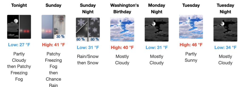
Tonight

Patchy freezing fog after 2am. Increasing clouds, with a low around 27. Calm wind.

Sunday

A chance of rain after 3pm. Patchy freezing fog before 9am. Cloudy, with a high near 41. Calm wind becoming east around 5 mph. Chance of precipitation is 30%. New precipitation amounts of less than a tenth of an inch possible.

Sunday Night

Rain likely before 10pm, then snow. Low around 31. Northeast wind 5 to 10 mph. Chance of precipitation is 80%. New snow accumulation of 1 to 2 inches possible.

Washington’s Birthday

Mostly cloudy, with a high near 40. North wind 5 to 10 mph.

Monday Night

Mostly cloudy, with a low around 31. Calm wind.

Tuesday

Partly sunny, with a high near 46.

Tuesday Night

Mostly cloudy, with a low around 34.

Wednesday

A chance of rain after 1pm. Mostly cloudy, with a high near 47. Chance of precipitation is 30%.

Wednesday Night

A chance of rain before 1am. Mostly cloudy, with a low around 40. Chance of precipitation is 30%.

Thursday

A chance of rain. Partly sunny, with a high near 53. Chance of precipitation is 30%.

Thursday Night

A chance of rain. Mostly cloudy, with a low around 38. Chance of precipitation is 40%.

Friday

A chance of rain. Mostly cloudy, with a high near 49. Chance of precipitation is 50%.

Friday Night

A chance of rain. Mostly cloudy, with a low around 36. Chance of precipitation is 40%.

Saturday

A chance of rain. Partly sunny, with a high near 48. Chance of precipitation is 30%.

Additional Forecasts and Information

Zone Area Forecast for Camden County, NJ

Camden County Office of Emergency Management issues “Code Blue”

The Camden County Office of Emergency Management declared that Camden County will be under a Code Blue Advisory from for the following dates and times due to projected dangerously low temperatures by the National Weather Service:

Monday, February 9 7:00 a.m. – Tuesday, February 10 7:00 a.m.
• Projected temperature: 15°F
Tuesday, February 10 7:00 p.m. – Wednesday, February 11 7:00 a.m.
• 
Projected temperature: 28°F
Wednesday, February 11, 7:00 p.m. – Thursday, February 12 7:00 a.m.
• 
Projected temperature: 25°F
Thursday, February 12 7:00 p.m. – Friday, February 13 7:00 a.m.
• Projected temperature: 20°F
Friday, February 13 7:00 p.m. – Saturday, February 14 7:00 a.m.
• Projected temperature: 19°F

Code Blue Advisories are declared when the National Weather Service predicts that the temperature is 32 degrees Fahrenheit or lower, or the wind chill temperature will be zero degrees Fahrenheit or lower for a period of two hours or more.

Continue reading “Camden County Office of Emergency Management issues “Code Blue””

Alert: Extreme Cold Warning until 10:00AM Sunday

* WHAT…For the High Wind Warning, northwest winds 20 to 30 mph with gusts up to 60 mph expected. For the Extreme Cold Warning, dangerously cold wind chills as low as 14 below expected.

* WHERE…Portions of Delaware, northeast Maryland, and southern New Jersey.

* WHEN…For the High Wind Warning, from 8 AM to 9 PM EST Saturday. For the Extreme Cold Warning, from 3 PM Saturday to 10 AM EST Sunday.

* IMPACTS…Damaging winds will blow down trees and power lines. Widespread power outages are expected. Travel will be difficult, especially for high profile vehicles. The cold wind chills as low as 15 below zero could result in hypothermia if precautions are not taken.

* AFFECTED AREAS: NEW CASTLE … KENT … INLAND SUSSEX … DELAWARE BEACHES … QUEEN ANNE’S … CAROLINE … SALEM … OCEAN … CUMBERLAND … ATLANTIC … CAPE MAY … ATLANTIC COASTAL CAPE MAY … COASTAL ATLANTIC … COASTAL OCEAN … SOUTHEASTERN BURLINGTON

Instructions:Remain in the lower levels of your home during the windstorm, and avoid windows. Watch for falling debris and tree limbs. Use caution if you must drive. Dress in layers including a hat, face mask, and gloves if you must go outside.

 Wind Advisory until 09:00PM Saturday

* WHAT…For the Wind Advisory, northwest winds 15 to 25 mph with gusts up to 55 mph expected. For the Extreme Cold Warning, dangerously cold wind chills as low as 17 below expected.

* WHERE…Portions of New Jersey and southeast Pennsylvania.

* WHEN…For the Wind Advisory, from 8 AM to 9 PM EST Saturday. For the Extreme Cold Warning, from 3 PM Saturday to 10 AM EST Sunday.

* IMPACTS…Gusty winds will blow around unsecured objects. Tree limbs could be blown down and a few power outages may result. The cold wind chills as low as 15 below zero could result in hypothermia or frostbite if precautions are not taken.

* AFFECTED AREAS: HUNTERDON … SOMERSET … MIDDLESEX … WESTERN MONMOUTH … EASTERN MONMOUTH … MERCER … GLOUCESTER … CAMDEN … NORTHWESTERN BURLINGTON … DELAWARE … PHILADELPHIA … WESTERN CHESTER … EASTERN CHESTER … WESTERN MONTGOMERY … EASTERN MONTGOMERY … UPPER BUCKS … LOWER BUCKS

Instructions:Winds this strong can make driving difficult, especially for high profile vehicles. Use extra caution. Dress in layers including a hat, face mask, and gloves if you must go outside.

Camden County Office of Emergency Management issues “Code Blue”

The Camden County Office of Emergency Management declared that Camden County will be under a Code Blue Advisory from for the following dates and times due to projected dangerously low temperatures by the National Weather Service:

Wednesday February 4, 7:00 a.m. – Monday February 9, 7:00 a.m.

• Projected temperature: Below freezing throughout the timeframe.

Code Blue Advisories are declared when the National Weather Service predicts that the temperature is 32 degrees Fahrenheit or lower, or the wind chill temperature will be zero degrees Fahrenheit or lower for a period of two hours or more.

“As temperatures fall to dangerously low levels, it is critical that our residents have access to a safe place to stay warm,” said Commissioner Jonathan Young, liaison to the Camden County Department of Public Safety. “We urge everyone to check in on vulnerable neighbors, ensure heating systems are working properly, and bring pets indoors.”

Continue reading “Camden County Office of Emergency Management issues “Code Blue””

Camden County Office of Emergency Management issues “Code Blue”

The Camden County Office of Emergency Management declared that Camden County will be under a Code Blue Advisory from for the following dates and times due to projected dangerously low temperatures by the National Weather Service:

Sunday, February 1, 7:00 a.m. – Wednesday, February 4, 7:00 a.m.

• Projected temperature: Below freezing throughout the timeframe

Code Blue Advisories are declared when the National Weather Service predicts that the temperature is 32 degrees Fahrenheit or lower, or the wind chill temperature will be zero degrees Fahrenheit or lower for a period of two hours or more.

“As temperatures fall to dangerously low levels, it is critical that our residents have access to a safe place to stay warm,” said Commissioner Jonathan Young, liaison to the Camden County Department of Public Safety. “We urge everyone to check in on vulnerable neighbors, ensure heating systems are working properly, and bring pets indoors.”

Continue reading “Camden County Office of Emergency Management issues “Code Blue””

When Weather and Walkways are Treacherous, Slow and Steady is the Way to Go

 by Hospital for Special Surgery 

Aleksey Dvorzhinskiy, MD, Orthopedic Trauma Surgeon at Hospital for Special Surgery

Newswise — The snow storm and freezing temperatures have turned many streets into obstacle courses. Snow and ice on the ground present hazardous conditions that could lead to a fall if people are not careful.

“An invisible patch of ice is an accident waiting to happen,” according to Aleksey Dvorzhinskiy, MD, an orthopedic trauma surgeon at Hospital for Special Surgery (HSS) in New York City at HSS Long Island in Uniondale. “People often forget how dangerous a fall can be, especially when they’re in a hurry to get somewhere.”  

Dr. Dvorzhinskiy says everyone should exercise caution after a snow storm. Even after much of the snow and ice is removed, there are always some slippery surfaces to watch out for. 

Continue reading “When Weather and Walkways are Treacherous, Slow and Steady is the Way to Go”

N.J. School Closures, Delayed Openings for Monday, January 26

Photo: istockphoto.com

New Jersey

Alice Costello Elementary School, Brooklawn (Camden) – Closed

Audubon School District (Camden) – Closed
Bellmawr Borough School District (Camden) – Closed.
Benjamin Banneker Prep Charter School (Burlington) – Closed.
Burlington Co. Inst. of Technology BCIT (Burlington) – Closed.
Burlington County Special Services (Burlington) – Closed.
Camden City School District (Camden) – Closed.
Center for Education (Burlington) – Closed.
Ewing Township School District (Mercer) – Closed.

Gloucester Catholic High School (Camden) – Closed.

Gloucester City School District (Camden) – Closed.
Haddon Heights School District (Camden) – Closed.
Hainesport Township School District (Burlington) – Closed.
Lenape Regional School District (Burlington) – Closed.
Lewis School of Princeton (Mercer) – Closed.
Little Kids College – Tremont St (Mercer) – Closed.
Little Kids College-Cherry St (Mercer) – Closed.
Little Kids College-Lawrenceville (Mercer) – Closed.
Lumberton Township School District (Burlington) – Closed.
Medford Township Public Schools (Burlington) – Closed.

Mount Ephraim School District (Camden) – Closed

Parkview Elementary School, Westville (Gloucester) – Closed
Penns Grove-Carneys Point Regional (Salem) – Closed.
Pineland Learning Center (Cumberland) – Closed.
Shamong Township School District (Burlington) – Closed.
St Augustine Prep (Atlantic) – Closed.
St. Cecilia School (Camden) – Closed.
Vineland City School District (Cumberland) – Closed.
Westampton Township School District (Burlington) – Closed.
Weymouth Township School District (Atlantic) – Closed.
Winslow Township School District (Camden) – Closed.

Camden County Emergency Operations Center Has Been Activated in Response to Severe Winter Storm

The Camden County Office of Emergency Management has activated the Emergency Operations Center (EOC) in response to Sunday’s severe winter storm.

“The EOC functions as our nerve center throughout the storm, and it will be where we will allocate assets wherever they may be needed across Camden County,” said Commissioner Jonathan Young, liaison to the Camden County Department of Public Safety. “We remain in constant communication with our state and local partners to ensure that our residents are safe throughout the duration of this storm.”

Camden County’s Department of Public Works and Camden County Parks Department will be working throughout the storm to ensure that county roadways are passable and respond to downed trees and debris. At the public works complex in Lindenwold, more than 100 pieces of equipment are available to keep county roadways passable. When the weather becomes treacherous, personnel will be dispatched to 12 winter maintenance districts to salt and plow 1,200 lane miles of roadways across Camden County. The county’s response plan calls for crews to be dispatched only to the zones where they are needed.

Continue reading “Camden County Emergency Operations Center Has Been Activated in Response to Severe Winter Storm”